
Recently, Government announced that there will be liberal geo-spatial data policy for providing remote-sensing data to tech-entrepreneur. This will provide a huge boost to the rapidly growing sector of remote sensing. In almost a decade, it has created a significant mark in agriculture by enabling the acquisition of the infield data without making any physical contact with the agricultural fields! From satellite imagery based remote sensing to use of Unmanned Aerial Vehicles (UAVs) popularly known as drones, remote sensing has facilitated data collection from complex landscapes such as inclined or terraced fields, different soil types, and highly heterogeneous small farmer plots. It has enabled timely estimations of crop acreage, forecasting sowing/ harvesting time, crop damages, draught assessment, cropping system analysis, crop yields at any given time, identification of pests and diseases, management of irrigation based on soil moisture, crop intensification, and in weather monitoring among many other of its applications. Regardless of national, regional, or local level, information gained from remote sensing has the potential to facilitate timely decision and make valuable inferences regarding market forecasts, production, economic impacts, and related decisions. Due to COVID19, visiting fields and collecting data is going to be challenging, as a result remote sensing applications would find several uses.
The global remote sensing services market is projected to grow at a CAGR of 15.14% to USD 21.62 Billion by 2022 owing to the growing popularity. Globally there are around 145 drone companies and it is expected to grow further. New exciting trends have been emerging resulting from evolving business models, dynamic market, and advent of technology. Additionally, the introduction of cloud computing and Big Data analytics in remote sensing are predicted to drive the demand for remote sensing services. Antrix Corporation (India), Maxar (DigitalGlobe, US), Remote Sensing Solutions (Germany), Terra Remote Sensing (Canada), EKOFASTBA (Spain), Geo Sense (Malaysia) and Mallon Technology (UK) are few of the key market players globally. Many Indian agtech companies have been rapidly establishing and expanding their global presence in this space. A recent trend of companies entering the Indian agricultural market as imagery processing providers has also been observed. Few of the leading companies globally which process the satellite images and extract the required data from the images include: Ceresimaging, Hummingbird Technologies, Orbital insights, IBM, Descartes Labs, Geosys.
Remote sensing, although not a very new tool for monitoring and analyzing agricultural activities, has proven vital for assisting decisions regarding industry investments, business agreements, etc. due to its ability to provide forecasts and valuable insights for precision agriculture. As the technology is improving, powerful sensors are being developed, effective prediction models are being generated and powerful tools for image analysis and interpretation are being developed to utilize the full potential of remote sensing and GIS. In India, currently, Remote sensing using Stratification optimization, pixel optimization and Early Warning Systems (EWS) are optimized with more than 90% national coverage for the major 8 crops including rice, wheat, cotton, sugarcane, jute, rapeseed, mustard, and Rabi sorghum are monitored through radar and optically (Ray et al., 2014). The use of remote sensors in agriculture has been rapidly increasing and few of the fields where remote sensing has been proved effective include:
- Crop Classification: Use of Hyperspectral sensors have enabled not only detailed crop classification, but also crop acreage and forecasting yield. Detailed analysis of these parameters is done through imaging and image processing techniques with high precision which enables distinction between different crops.
- Crop Health Assessment: Tracking and assessing crop health by following physiological changes in the crops is done through spectral analysis of various parameters such during the different stages of crop growth. Yields forecasts can be made through remote sensing by deriving the relationships between vegetation indices and crop yield.
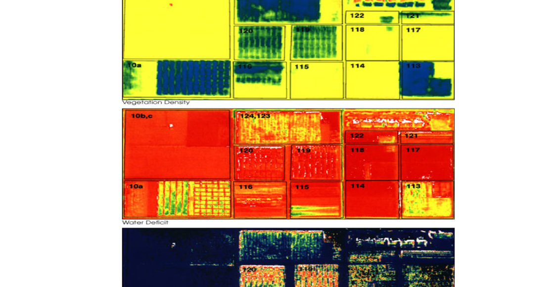
- Pest & Disease Management: High resolution multispectral remote sensing can facilitate accurate monitoring of diseases and pests in crops and provide advisory about management strategy. Based on the correlation of different patterns of defoliation of leaves associated with different diseases or pest, predicting, and managing the pest/ diseases can be also done.
- Nutrient & water Assessment: Using remote sensing and Geographic Information System (GIS), site specific nutrient deficiencies can be detected and addressed. Water use efficiencies can be maintained by using models to measure temperatures which can monitor the water use efficiencies. Using Vegetation indices such as Normalized Difference Vegetation Index (NDVI) and Vegetation Condition Index (VCI) and GI, predictions on stressed and non-stressed plants can be made.
- Weed Management: Remote sensing can facilitate weed management through site specific weed mapping using the differences in spectral reflectance between the weed and crop. Using the radiance ration and NDVI, weeds can be identified and managed with the help of GIS (Kaur et al., (2013)).
- Precision Agriculture: Precision agriculture offers the tools and technologies to identify in-field crop and soil variabilities, offering a way to improve farming practices and optimizing agronomic inputs. Remote sensing is key to precision agriculture. Use of handheld or tractor mounted sensors, satellite, and aerial imagingby wavelengths from ultraviolet to microwave portions of the spectrum has improved accuracy of precision agriculture.
Different prediction models can be built based on various geological parameters and precise predictions can be made at farm level to decide the exact course of action for effective farm management using remote sensing images. For remote sensing images may be captured through sensors or electromagnetic radiation using satellite imaging or UAVs But Each of the remote sensing devices have their own spectral band and hence data captured from one device cannot be directly compared to the data captured by other remote sensing device. It is also critical to know that high special resolution will provide lower temporal resolution and vice versa. So, depending upon the application, remote sensing models and data captures must be used.
As per the latest Government announcement, the private sector will also get access to ISRO’s currently used cartosat-1 and 2 (Cartography satellite), Resourcesat (Multispectral imaging satellite), Risat-1 (Radar imaging), Kalpana1 & INSAT (Meteorological forecasting and observation) for remote sensing of all weather, dawn-to-dusk imaging, disaster management and agricultural monitoring. Access to these sophisticated ecosystems will provide a platform to nurture entrepreneurship throughout India including the rural areas which offer the advantages of field-testing on farms which are critical for obtaining quality assurance certifications, marketreadiness of the final technology product, and generating systematic upgrades based on direct feedback from farmers. ISRO in collaboration with private sector is planning to launch satellites to meet the growing demands and to augment the overall capacity. With the changes in the regulatory environment and policies which will be introduced shortly, Private sector will get the opportunity to explore and rapidly grow in this sector. Although, in India there are a lot of small holding farms which pose a challenge in implementing these technologies, digitization of farmlands as proposed and prioritized by the Government and the support provided by the Farmer Producer Organizations (FPO) can empower the farmers to embrace remote sensing technologies to make agriculture a scalable and sustainable sector. Hence, remote sensing is undoubtedly the future of Agritech and a tool to facilitate resilient growth in agriculture and make it viable!
Author

Connect with Authors at: E-mail agribusiness@sathguru.com

